

“So geographers in Afric maps
With Savage pictures fill the gaps
And over Uninhabited downs
Place elephants for want of towns”
/ Research - Igbo Architectural Heritage
For many centuries, sub saharan architecture has been seen as primitive, However Igbo architecture can also be seen as the product of physical and cultural factors, which create architectural problems and also provide some means of solving them. The physical environment, for instance, causes the problems of rain, heat and humidity, but provides mud, timber, bamboo and palms for house building. In the current climate where ideas of de-growth and challenging consumption are gaining traction, the traditional architecture adheres to the basic sustainability principles of energy efficiency and utilization of materials /resources in close proximity to the site. A taxonomy of traditional Igbo architecture was conducted to see what aspects could be relevant in the modern day


“When we gather together in the moonlit village ground it is not because of the moon. Every man can see it in his own compound. We come together because it is good for kinsmen to do so.
”


/ Research - Umuahia
The site is located in Umuahia, capital of Abia state, which lies along the railway between the major urban centres of Port Harcourt and Enugu. It is an agricultural market centre. In precolonial times, it served as one of the central marketplaces in the region for commerce. Currently being the state capital it is also an administrative centre and many people are employed as civil servants.
Originally a village group, in line with colonial policy, it was developed into a town from its constituent villages. Since 1916 it became a collecting point on the railway for the crops of the surrounding region.
Colonial map of Umuahia - The settlement served as an administrative centre and a collecting point for crops and commerce due to the trainline running through it. It was segregated into European and native areas
Current Map - Rapid urbanisation has caused the city to expand into its constituent villages


Due to rapid urbanisation, The city of has expanded majorly into the surrounded villages and many have found themselves in the middle of the crossroads heading in and out of the city. The city faces many challenges but most relate to overcrowding due to urbanisation\ poor roads, lack of formal infrastructure, for example sanitation, drainage and piped water and a lack of access to communal space.
Ride through Umuahia
Two areas in particular were studied to try and identify a target group of residents for my scheme, and look at a cross section of living conditions. The World Bank Housing Estate a middle income area, and what was originally the ‘natives reservation’, a low income area showing a continuation of the original grid iron pattern, established by the British.
World Bank Housing Estate - Typical street section
World Bank Housing Estate - Plan of studio unit shared by husband wife and 2 children

Old natives reservation - grid iron pattern

Old natives reservation - View through verandah to courtyard, early town compound

Old natives reservation - Early post colonial building built by early town dwellers during first period of urbanisation

Tenement building - Axonometric drawing of typical tenement building in old natives reservation. Originally built for people moving to newly formed towns for work

Tenement building - Originally built for a single extended family, now several families can occupy one or more rooms. Rooms facing the street can also be rented out as shops
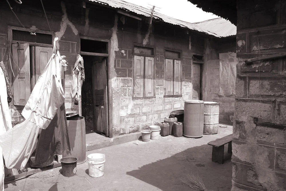
Tenement building - Courtyard

Tenement building - Kitchen
/ Research - Site
The 1.9 hectare site is comprised of virgin land to the north east of the city, near Okwuta village in an area which is rapidly becoming more central due to urban sprawl.
Currently populated with palm trees and undergrowth, the site slopes from the north east to the south west, a height difference of approximately 10m with a south westerly prevailing wind. The roads around the site are in poor condition but will likely be upgraded in future due to the areas development
Existing site plan - Development has been rapid, but slower than possible due to the difficulty in titling ancestral lands


Typical house types - The creation of a new government complex near the site has made the land more valuable, and many large houses are springing up on the previously undeveloped land.

Typical settlment pattern - Site as would be typically laid out in a modern housing estate